The Great Highway Robbery: Historic Freedmen Towns and Texas Highways
The history of highway construction in Texas cities offers a glimpse into the dark infrastructure of public policy and design. Postwar urban infrastructure projects had devastating consequences for historic Black communities, or freedmen towns, in Dallas and Houston. Following the Urban Renewal Act of 1949, city planning has demonstrated a pattern of targeting African American communities, dividing cities along racial lines and restricting physical access into and out of neighborhoods, which dispossessed residents of property and community, further compounding the hardships of residential segregation.
Segregation in the South was the practice of “geographically separating peoples as a way of making and fixing absolute segregation laws,” thus limiting African Americans’ “representational mobility” (Hale 2010, 8). In Making Whiteness: The Culture of Segregation in the South, 1980–1940, Grace Elizabeth Hale argues that after the Civil War, in the South “racial identity became the paramount spatial mediation of modernity within the newly reunited nation” (7). This spatial mediation would come in the form of racial zoning, which Christopher Silver provides evidence of in The Racial Origins of Zoning in American Cities. Silver argues that in the early part of the twentieth century, Southern cities engaged in a practice of enacting extralegal methods of racial zoning in order to create completely separate Black communities and to “enforce the newly created system of racial segregation” (Silver 1997, 1). Silver points out the integral role that urban planning played, in conjunction with legal prohibitions against racial intermingling, toward allowing cities to enact extralegal processes that would create separate racial worlds with physical “barriers to social interaction” (5).
During the middle of the twentieth century, automobiles transformed the American landscape and significantly redistributed the focus of urban/suburban architecture, infrastructure, and landscape design. In response to the phenomenon of “white flight” to the suburbs, the Urban Renewal Act of 1949 sought to address the decline of urban housing by enabling the federal government to provide support for cities in order to clear urban “slums” of “blight” and make way for redevelopment. Urban renewal projects disproportionately impacted African Americans. For example, though Blacks comprised 10 percent of the US population in 1969, they made up 66 percent of the population in areas planned for urban renewal (Fullilove 2001, 76). In many cities such as Dallas, planners set a path for highways to cut through predominantly African American and Latinx urban communities. The result was that historical neighborhoods of color were cut off from the main streets and business sectors of the city by highway access roads and the absence of through streets. These neighborhoods dissolved, becoming even more geographically isolated while being cleared for development, thus blocking economic growth and opportunities to accumulate generational wealth. In “Root Shock: The Consequences of African American Dispossession,” Mindy Fullilove explains that “community dispossession—and its accompanying psychological trauma, financial loss, and rippling instability—produced a rupture in the historical trajectory of African American urban communities” (2001, 78).
In “Under Asphalt and Concrete: Postwar Urban Redevelopment in Dallas and its Impact on Black Communities, 1943–1983,” Cynthia Lewis articulates the compounded effect created by residential segregation strategies in early twentieth-century Dallas. Discriminatory housing codes and deed restrictions passed by Dallas city leaders limited Black Dallasites to eight established neighborhoods. Most of these communities were original freedmen towns, having been first settled in the late 1870s and ’80s by free Blacks. As a result of residential segregation in Dallas, these enclaves grew into economically self-sufficient, tight-knit communities (Lewis 2019, 33). Urban population growth in the 1920s and ’30s saw rural Blacks move to the city, seeking jobs yet overcrowding the limited housing in established Black neighborhoods. Overcrowding led to structural deterioration and conditions of blight, cited by the city to further rationalize their “slum clearance projects” (58).
The urban highway system in Dallas provides many examples that contextualize the devastating impact this aspect of urban renewal had on Black residents. The construction of the first section of the Central Expressway (CE) bisected and cut through North Dallas Freedman Town in 1949. As it expanded south in 1950, the CE’s access roads and intersections destroyed Black businesses and entertainment venues in Deep Ellum and completely destroyed neighboring Stringtown (Lewis 2019, 12). In 1956, the South Central Expressway expanded south through the Black residential neighborhood of Bon Ton, which was further divided in 1964 by the H.C.F. Hawn Freeway. The South R.L. Thornton Freeway, which opened in 1959, destroyed the business district of the Tenth Street neighborhood and cut off easy access into and out of the area. In total, urban highway projects in Dallas destroyed over three hundred Black-owned homes and displaced thousands of Black residents, further exacerbating the housing crisis and destabilizing the social and economic centers of Black life in Dallas (38).
In preparation for the reconstruction of the North Central Expressway (NCE), a 1985 survey revealed that, during the freeway’s original construction in the 1940s, a southbound frontage road had been built directly over Freedman’s Cemetery. The original neighborhood, Stringtown, had been a freedmen’s town established after the Civil War, positioned between Freedman Town and Deep Ellum. Located near the downtown origin of the CE and formerly bordering the H&TC railroad, Stringtown’s historic cemetery had been active at the turn of the nineteenth century. During the first phase of construction of the CE, Freedman’s Cemetery was disturbed without an archeological survey (Slotboom and Slotboom 2014, 104). Exposure of this story and the ensuing public outcry led to an archeological survey and excavation that exhumed over one thousand remains and reinterred them between 1991 and 1994 at a new site. The Freedman’s Cemetery Memorial, built in the early 1990s, is now the final resting place for more than one thousand unmarked graves.[/commentable]
Similar to the Central Expressway project, the construction of the R.L. Thornton Freeway in Dallas’s Oak Cliff area fractured a thriving African American neighborhood now known as Tenth Street Historic District, founded in the late 1800s as a freedmen community southwest of downtown Dallas in Oak Cliff. By the 1950s, the Tenth Street neighborhood included at least two hundred homes and thriving businesses and provided an important social and commercial gathering place for Tenth Street residents as well as Blacks living in other areas of Dallas (Lewis 2019). The construction of I-35 East effectively isolated the neighborhood and destroyed successful Black-owned businesses and social spaces connecting Tenth Street to bustling Oak Cliff. The freeway blocked access, making it difficult to enter into and exit out of Tenth Street, which dealt a massive economic blow to the community. Families moved away for better opportunities, and by the 1990s many historic homes were abandoned and in disrepair, making them a target for city-clearing projects. Like many Black neighborhoods, the community has historically lacked basic public utilities such as street lighting, sidewalks, paved streets, and effective stormwater management. Fortunately, ongoing community advocacy and organization by residents’ neighborhood groups have resulted in increased awareness and action. The district was added to the National Register of Historic Places in 1994 and in 2019 and cited by the National Trust for Historic Preservation as one of the eleven most endangered historic places due to court-ordered demolitions. The Dallas City Council also passed a resolution in 2019 that prevents city resources from demolishing houses in the district unless mandated by the city fire marshal.
Dallas streetcars and the commuter rail were shut down in the late 1940s before the construction of I-35, suggesting that the proliferation of highways presaged the loss of public transportation. Tenth Street Historic District has a relic of an even earlier infrastructure project that shaped its urban geography even before the highway. Driving on East Clarendon Drive, the remnants of the supports for the interurban bridge named the Clarendon Trestle (or Oak Cliff Viaduct) cross the street. Clarendon Trestle was a raised commuter rail bridge that bounded the Tenth Street district on the east, providing electric streetcar access to and from Tenth Street’s business district. Clarendon Trestle is historically significant as the first public infrastructure project led by an all-African American construction crew (Herring 2021, 1). Now its crumbling trestles stand as a monument to Tenth Street and a reminder of once-vibrant streetcar systems and our country’s disinvestment in railroad infrastructure in favor of cars. Established in the early 1900s, the Trinity Heights streetcar “bolstered the growth” of Tenth Street and facilitated travel from Oak Cliff to downtown and between Black communities (Lewis 2019, 39). The loss of the commuter rail system further limited Black residents who relied upon it to commute to jobs and access Black-owned businesses and cultural institutions in racially segregated Dallas.
In present-day Houston, highway expansion threatens to encroach even further on Independence Heights, a Black neighborhood impacted by the construction of the I-610 and I-40 interchange in 1959. Independence Heights, the first incorporated Black municipality in Texas, was founded on the outskirts of Houston in 1908. By 1929, the residents voted to be annexed by Houston with the hope that, by joining the city, the neighborhood would benefit from public utilities and infrastructure support (Longoria and Rogers 2013, 28). Yet, many of these improvements never manifested. In the oral history project “Independence Heights: A Portrait of a Historic Neighborhood,” Rice University and middle school students collected oral histories from residents who described the daily hardship of navigating unpaved streets well into the 1950s and the lack of streetcar and later bus service for residents commuting to work in other parts of the city (Allen, Cyrus, and Seals 2003, 3). The construction of the 610 and I-45 interchange geographically isolated the neighborhood from access to greater Houston, bounded by I-610 on the south and I-40 on the east. Through eminent domain, more than 250 homes, churches, and businesses were displaced, unraveling the social fabric of the community.
In 2015, the North Houston Highway Improvement Project proposal to widen and expand the number of lanes on I-45 threatened residents with further loss of property, including such important community spaces as the Mount Olive Missionary Baptist Church (“Texas’ $7 Billion Plan to Remake Houston Highways Once Again Targets Homes, Businesses in Communities of Color” Texas Tribune, October 11, 2019). The I-45 expansion project has met with opposition from community groups and gained national visibility. As a result, the US Department of Transportation, with support from the White House, paused all work to investigate potential violations of Title VI of the Civil Rights Act. Tanya DeBose, executive director of the Independence Heights Redevelopment Council, warns that “the continued devaluation of property, forced displacement of people, massive flood events, and the expansion of freeways, railroads and transportation routes through communities of color will erase the culture of these unique places” (2019, 1).
Delores Hayden, in her book The Power of Place, uses Henri Lefebvre’s theories of the “production of space” to highlight the “territorial history of the city based on race or gender” (1999, 22). Lefebvre argues that space is socially produced, being determined by economic production and the political economy and, in turn, reproduces social hierarchies. Hayden emphasizes Lefebvre’s theories to argue that “one of the consistent ways to limit the economic and political rights of groups has been to constrain social reproduction by limiting access to space” (22).
The dark history of Texas’s urban highways chronicles how racial discrimination is practiced, enforced, and articulated through spatial policies. Racial inequality and disparity become manifest through policies that fracture and threaten to erase historic urban communities. Discriminatory policies in housing and education and the design of public infrastructure continue to erode historic Black communities, such as Freedman Town, Tenth Street, and Independence Heights.

References
Commentary by Juuso Tervo
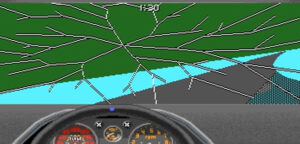
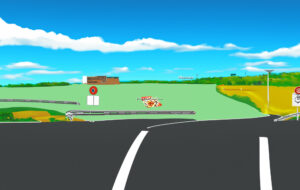
The shadowless noonday drive depicted in Libersat’s Endless Highway bears distant similarities with the MS-DOS game Stunts I remember playing in the early 1990s; a game that, like Endless Highway, positions the gamer in a car driving against a somewhat indistinct blue-green background. There are, of course, crucial differences between the two. In Stunts one is expected to compete with other drivers by driving as fast as one can through peculiar ramps and obstacles, often leading to then-realistic depictions of cars crashing violently on each other or on the structures forming the racetrack. In Endless Highway destruction is certainly present, but in another form: it is the very condition of possibility of the highway we see ourselves faring through; it resides in the smoothness of this endless (Moebius’s) strip. Violence and destruction in Endless Highway are, in a word, infrastructural.
Immersed in Libersat’s loop and its graphics, I began to wonder what it might mean to address these forms of violence simultaneously under the sign of yet another dark infrastructure, that of AI. By using “endless highway” as my command, I let Photoshop’s new AI function generate new material from two scenes of destruction I found from someone’s Stunts gameplay.


Perhaps not surprisingly, violence blends smoothly to the rest of the image and becomes part of the generic landscape the AI is taught to dream of. The chimeric quality of the generated images is mere surface: as suggestions, they seem to strive for clarity. They put us on the road again, as Willie Nelson once sang, faring through a graphic landscape parsed together from acts of destruction. Like in Endless Highway, in the background we hear the steady hum of infrastructures closing onto themselves—some computations somewhere, elsewhere.
